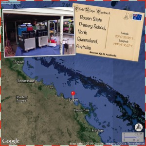
Do you want a great way to connect with others globally – why not try the Photo Mapo App? Photo Mapo is an easy way to use Google Earth Maps to turn your map into a photo collage using one of 13 different background styles (postcards, treasure map, retro ) on you mobile device.
Add photos and text descriptions. Choose what information you would like displayed on your map i.e. time and date, latitude and longitude, direction, city, state, country, map scale and a compass rose.
Once you have designed your photo-map, share it on social media or save it to you mobile device.
I am presently using this app for my Year 2 geography unit entitled ‘My Place in the World’. What a great way to explore the world and then zoom into our hometown. We then add photos of our school and save the photos. We will make the photos into a book at the end of the unit.
Richard Bryne on his Blog Free Technology for Teachers has fantastic ideas on app smashing (combining apps) using Photo Mapo. I really like the idea of collecting all the student photos, using the app Book Creator to add narration and then creating augmented reality postcards.
Photo Mapo is available for IOS and android devices at the app shop.
You can follow Photo Mapo on Facebook and Twitter (@PhotoMapo)
KM 🙂
